Katsushika, Tokyo Prefecture –
Si sente spesso parlare di quanto estesa sia Tokyo, di come da uno qualsiasi dei grattacieli del centro non si riesca a vederne la fine. Una distesa infinita di costruzioni che nei giorni più limpidi sembra estendersi fino ai piedi del monte Fuji. È certo che ne esista una fine amministrativa, un confine oltre il quale la municipalità lascia il controllo alla città successiva. Molta di questa infinita area urbana è composta da diverse città che negli anni del progresso economico si sono espanse a tal punto da far combaciare i confini, senza lasciare spazio ad alcuna zona non edificata.
Il progetto Nipponia vuole raccontare le zone rurali del Giappone, alla ricerca di un’atmosfera estetica puramente giapponese. Qualsiasi viaggiatore si troverà però a dover affrontare anche le grandi metropoli del paese, Tokyo prima di tutte. La fascinazione nei confronti del paese e della sua cultura parte proprio da qui ed è una tappa imprescindibile per capire l’altra faccia del paese, quella rimasta indenne dal progresso estremo di cui questa capitale è il simbolo. Spesso la prima “idea” che abbiamo del Giappone deriva proprio da ciò che immaginiamo sia Tokyo.
Ho sempre cercato di scovare nelle grandi città i residui di quello stile di vita cancellato dal progresso economico e tecnologico e con il definirsi del progetto Nipponia ho deciso di documentare le diverse realtà della periferia di Tokyo come testimonianza della complessità di questa meta cosi ampiamente rappresentata ma raccontata solo parzialmente.
È inutile dire che non è possibile visitare l’intera area in un unico viaggio per cui il progetto dal titolo “The end of Tokyo” verrà suddiviso in zone durante altrettante spedizioni.
↓


Camminare senza meta nei quartieri meno turistici di Tokyo è uno dei modi più efficaci per fare esperienza di un Giappone meno artefatto, simile a quello che trovereste in aree più remote. Non è un luogo preciso a portare con se questa atmosfera, la si può percepire in zone densamente urbanizzate o totalmente isolate. La sensazione di averlo trovato arriva all’improvviso, basta un respiro e ci colpisce in maniera inequivocabile. Avviene quando la luce del sole, l’odore dell’aria, il rumore del vento e le proporzioni degli spazi, creano la precisa impressione di essere all’interno di un’idea più che in un luogo reale. Mi è capitato diverse volte in Giappone, molte di queste a Tokyo.
Una prima visita alla capitale del paese obbliga il turista a partire dal centro. La linea ferroviaria Yamanote definisce l’area più visitata iscrivendo in un cerchio i quartieri più rilevanti della città. Molti visitatori non si spingono mai oltre i confini della linea circolare ma proprio all’interno di quell’area altrettanti si sentono sopraffatti.
Alcuni possono avvertire la città come respingente. Troppo caotica, troppo grande, con troppi stimoli visivi e auditivi. Una grande lavatrice colma di ogni tipo di impulso, che ruota senza sosta finendo per spingervi ai bordi con la sua forza centrifuga.
↓
Ho spesso assecondato questa spinta verso l’esterno che avvertivo ogni volta che trascorrevo del tempo in città, per molto tempo fuggendo verso le campagne finchè mi sono chiesto dove si affievolisse questa forza, dove – pur rimanendo dentro i confini della città – si vivesse ad un ritmo più lento.
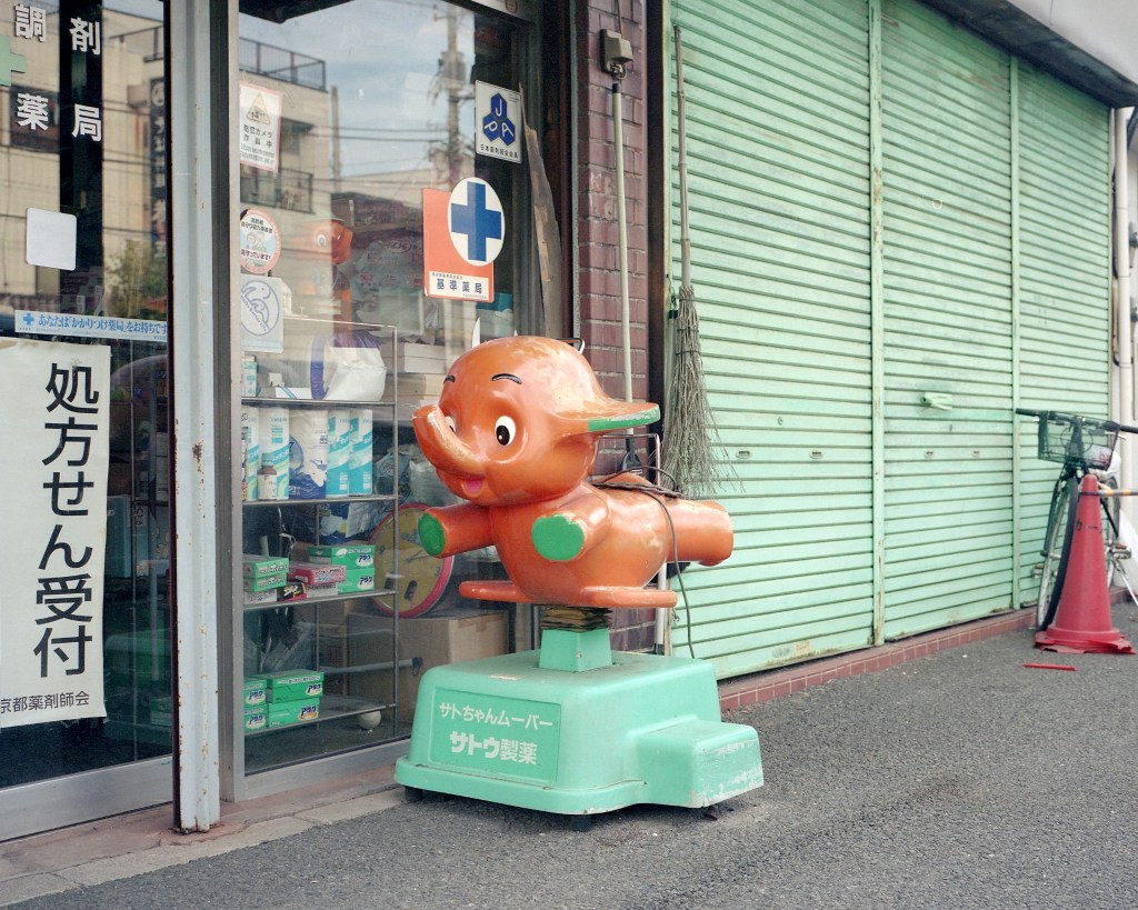
In alcuni sobborghi esterni è facile assaporare l’atmosfera leggera del quartiere a misura d’uomo. Trovare attorno alle piccole stazioni i soliti ristoranti e negozi con il via vai delle persone, una strada coperta per lo shopping (shotengai) dalla tipica architettura, mascotte sbiadite nelle vetrine delle farmacie, uffici postali tappezzati di promozioni, il negozio di soba o curry o unajyu (piatto a base di anguilla) dove c’e sempre una fila di due persone in attesa. Il contrasto tra questa Tokyo e quella del centro mi ha sempre fatto pensare a come sia impossibile definire il carattere di questa metropoli in un’unico modo.
Noi occidentali pensiamo a Tokyo con l’idea di città basata sulle nostre metropoli. Immaginiamo un identità definita seppur con le sue sfaccettature di quartieri e periferie. Un luogo in cui è possibile individuare gli strati del passare del tempo. Per una visita e un’analisi più accurata della città andrebbe ricordato che l’area metropolitana di Tokyo si estende per 1780 kilometri quadrati. Quest’area è definita dal perimetro governativo, amministrativo e tecnico della città. Se si considera però tutta l’area urbanizzata che si estende dal centro fino alle prime zone rurali dobbiamo includere circa 12350 kilometri quadrati di territorio, in cui vivono approssimativamente 42 milioni di persone. È impossibile quindi definire un’unica identità.
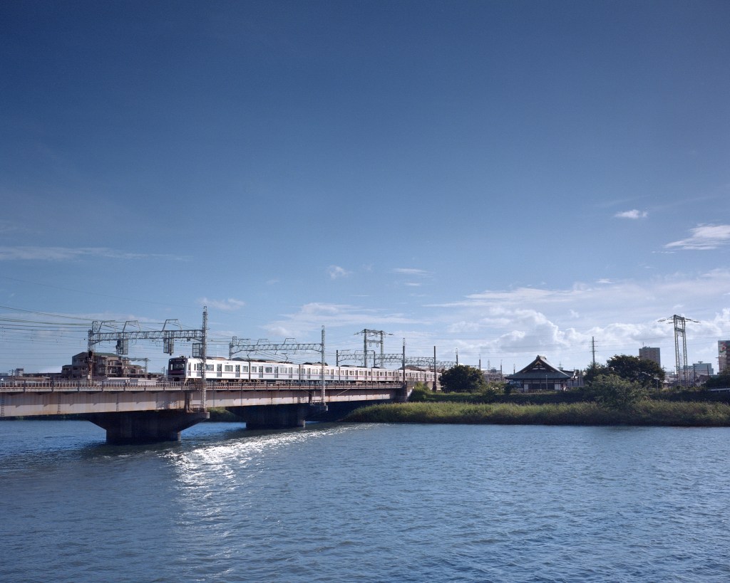
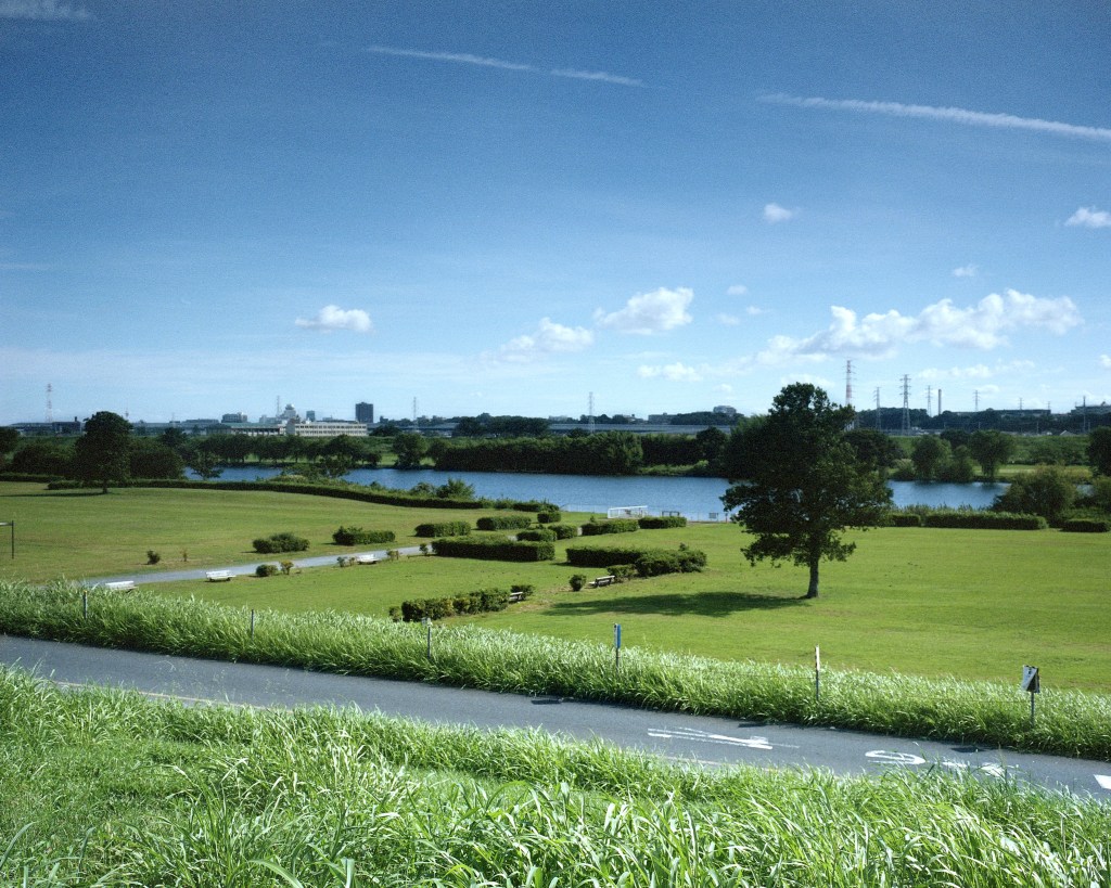
(a destra il fiume Arakawa che segna l’inizio del quartiere Katsushika, uno dei quartieri esterni di Tokyo)
↓
Alla ricerca di una sfumatura visibile, dove la caotica Tokyo del centro si mescola con uno stile di vita più semplice, mi sono spinto sempre più lontano non prima però di aver definito un limite.
Per questa ricerca ho preso in considerazione solo l’area amministrativa, quella citata in precedenza che si estende per 1780 kilometri quadrati.
L’area definita urbana, quella dei quartieri speciali come Shibuya, Shinkjuku o Ginza, si affaccia sull’oceano pacifico ed è l’area più visitata e densamente popolata della municipalità. Proseguendo verso ovest l’area viene definita suburbana amministrata sotto il nome di grande area Tama, divisa in zona Tama nord e Tama sud, e verso le montagne Tama Ovest. L’area metropolitana di Tokyo è cosi vasta da essere diventata una prefettura nel 1943 e include le catene di isole Izu e Ogasawara, quest’ultime situate a mille chilometri di distanza dalla baia di Tokyo. Tokyo è quindi a tutti gli effetti una regione, che include ventisei città, cinque paesi e otto villaggi ognuno dei quali ha un proprio governo locale. Gli stessi 23 quartieri zone speciali della zona urbana sono amministrati localmente con una certa autonomia.
Ho deciso quindi di documentare la linea di confine che definisce la fine di Tokyo per osservare se è percepibile una fine oggettiva, dove la città termina lasciando spazio alla natura, o al contrario osservare come la zona urbana si fonda con la successiva, facendo cosi diventare il concetto di confine meramente di valore tecnico.
↓
La prima tappa prende in considerazione uno dei 23 quartieri di Tokyo a nord\est della città, Katsushika. Qui il confine è ben definito a nord dal fiume Edo dando un’immagine concreta della fine della città.
Il panorama che si ammira dalle sponde del fiume è diventato popolare grazie ad una serie di film a partire dagli anni sessanta.
Intitolata Otoko wa tsurai yo (È dura essere un uomo) la serie diretta da Yoji Yamada racconta la vita di Tora-san, un venditore vagabondo che attraversa il paese ma fa sempre ritorno Shimabata, il quartiere che si affaccia sul fiume Edo.
In molte scene dei film il personaggio principale passeggia lungo l’argine e contempla il panorama oltre i confini della città. Tora-san è molto popolare in patria e in particolar modo qui a Shimabata dove è stato realizzato un museo che ne ricostruisce la storia attraverso scenografie e oggetti di scena. I film della serie riportano indietro all’epoca Showa e molte delle caratteristiche del tempo le potete ritrovare ancora oggi passeggiando attraverso il quartiere.
(a destra il confine naturale di Tokyo nel fiume Edo ai margini di Katsushika, oltre la sponda il territorio rientra nella prefettura di Chiba.)
↓
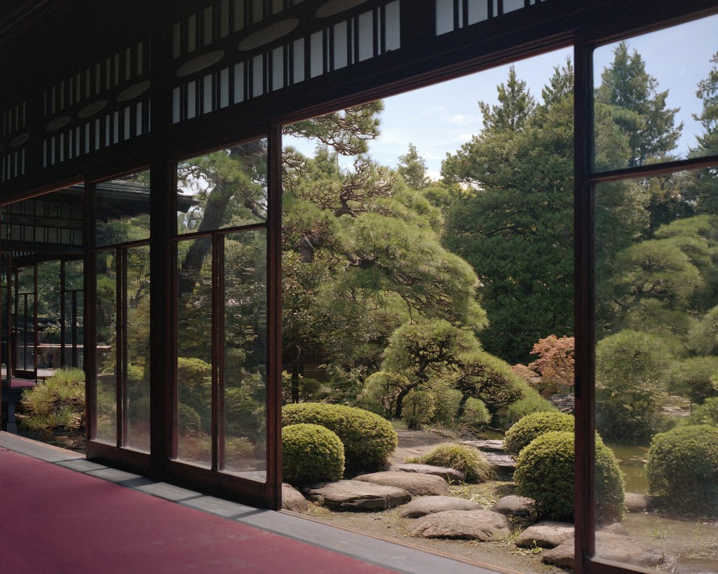
Poco lontano dal museo si può visitare un’abitazione privata ora aperta al pubblico, Yamamoto-tei. Costruita alle fine degli anni venti come residenza della famiglia Yamamoto, la villa mescola architettura tradizionale in stile shoin-zukuri con elementi in stile europeo.
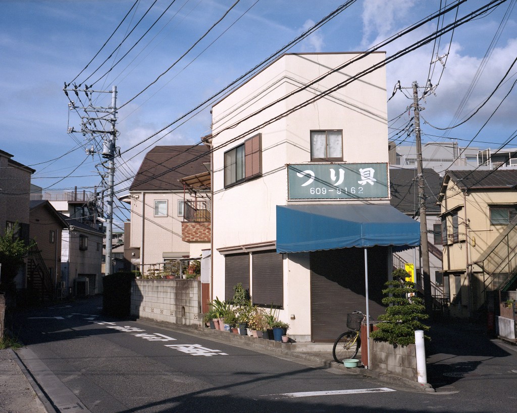
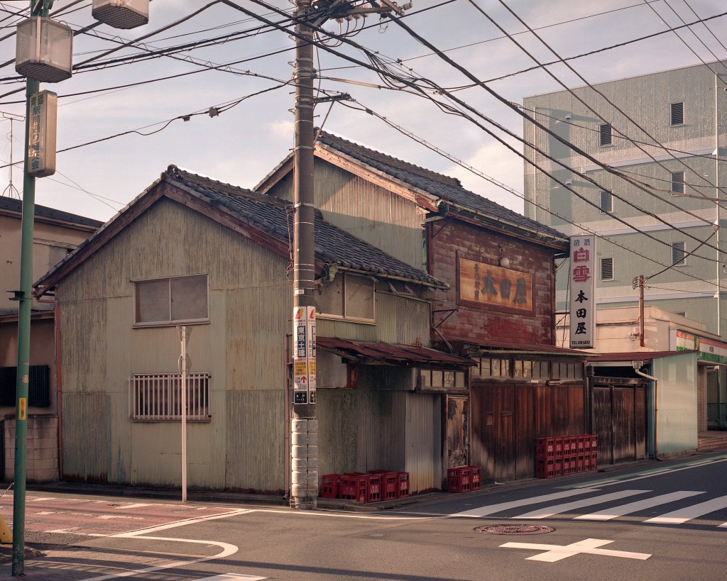
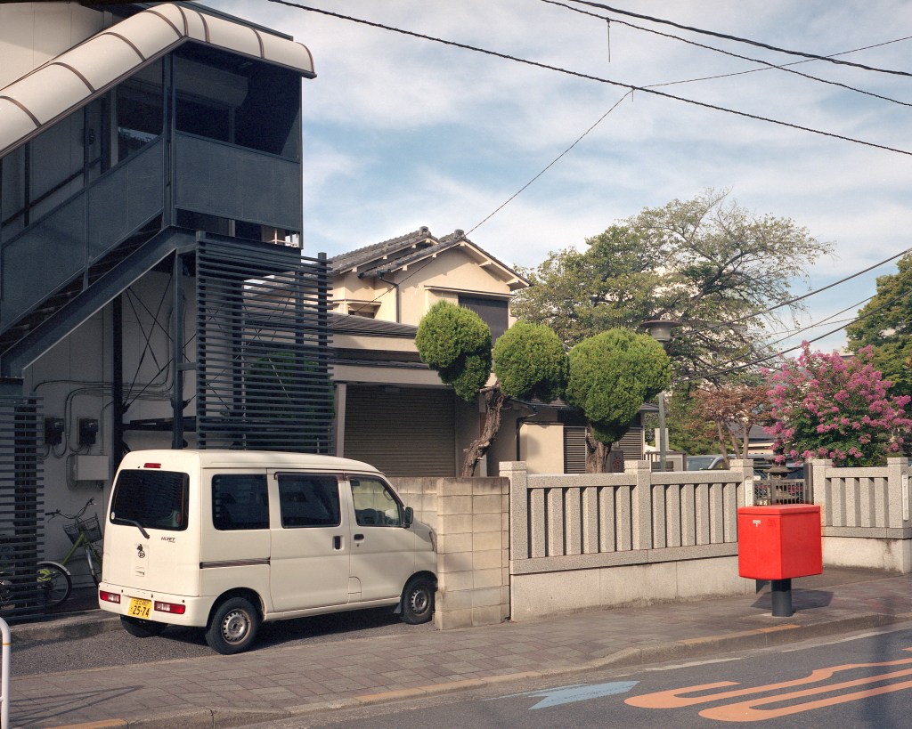
Dopo aver osservato il confine della città sul fiume Edo mi sono incamminato in direzione opposta, verso la baia di Tokyo. Ho attraversato tutta Katsushika, percorrendo stradine secondarie ed evitando le arterie commerciali o troppo trafficate. Per quanto le zone nei pressi delle stazioni ferroviarie siano colme di negozi, café e ristoranti, appena ci si allontana i rumori si affievoliscono, le insegne svaniscono e per lo più incontro signore di mezza età in sella a biciclette dagli squadrati cestini porta tutto, che sfrecciano sprezzanti e un pò infastidite dalla mia presenza ignara del loro ruolo di dominatrici del marciapiede.
Pare che in Giappone i marciapiedi siano in primo luogo delle piste ciclabili – nonostante una legge sancisca il contrario – regolamentate da un senso di marcia a me ancora sconosciuto. I pedoni devono guardarsi le spalle e stare sempre attenti che da dietro l’angolo non sbuchi una bici a tutta velocità. Il mio aspetto da occidentale mette in allerta i ciclisti che da lontano intuiscono la mia estraneità alle regole locali schivandomi con grande anticipo mentre mi acquatto ad inquadrare l’ennesima casa fatiscente. Attraverso Katsushika senza guardare la mappa, mi oriento con il rumore del treno che tengo circa alla stessa distanza per tutto il tragitto. Shimabata, Keisei Takasago, poi Aoto.
Seguo tra gli edifici il binario sopraelevato che divide i quartieri. Faccio tappa solo per dissetarmi alle vending machine. Mi stupisce sempre quante siano e fino dove si spingano i gestori per posizionarle, luoghi che non hanno nessuna apparente attrattiva e nemmeno un via vai cosi cospicuo da giustificarne la presenza. Se si osserva bene c’è sempre un motivo sull’ubicazione di una vending machine che a noi viaggiatori spesso sfugge. Anche la più nascosta è probabilmente direzionata verso l’uscita di un parcheggio per auto o bici o si trova in fondo alla scala di un edificio che ospita un karaoke o un salone di parrucchieri. Se c’è una vending machine un’attività con grande passaggio di persone è sicuramente nei pressi. Bevo un tè freddo al gusto di mela, poi uno tostato e un’altro che sa di alghe. Quest’ultimo lo finisco a fatica.
Le vending machine sono anche il luogo dove gettare la bibita acquistata alla tappa precedente, perché gli unici cestini all’aperto sono solitamente nascosti dietro di esse, e hanno una apertura sufficiente a inserirvi solo le lattine o le strette bottiglie di plastica acquistate nelle stesse.
L’unica tappa per riparami qualche minuto dal caldo di fine estate la faccio in un caffè di quelli che potete trovare solo in zone residenziali. Piccolo, spoglio ma con un certo senso estetico, un po retrò e con quell’influenza europea che i giapponesi hanno saputo rielaborare in uno stile tutto loro. Qui assaporo qualcosa che solo l’intraprendenza del giovane gestore del caffè poteva concepire. Mi spiega che ogni settimana propone una combinazione diversa, un’esperimento per spingere i clienti a pensare al caffè in un modo nuovo. Cosi mi delizia con un espresso versato in un grande bicchiere colmo di ghiaccio e acqua tonica. Il gusto amaro delle due bevande si mescola perfettamente e non posso trattenermi dal buttarlo giù in un solo sorso.
Sono quasi arrivato al termine del quartiere di Katsushika, seguo le curve del fiume Naka quando è già il tramonto. Raggiungo la sponda del fiume Arakawa. Da qui si distingue la torre Skytree che annuncia l’avvicinarsi dei quartieri centrali. Le foto che ho realizzato in questa prima spedizione raccontano un pò dell’atmosfera di questa Tokyo meno conosciuta e mostrano come sia possibile – almeno qui – definirne i limiti e trovarne la fine.
ENGLISH VERSION
We often hear about how large Tokyo is, how you can’t see the end of it from any of the skyscrapers in the center. An infinite expanse of buildings that on the clearest days seems to extend to the foot of Mount Fuji. It is certain that there is an administrative end to it, a boundary beyond which the municipality leaves control to the next city. Much of this infinite urban area is made up of several cities which, over the years of economic progress, have expanded to the point that their borders overlap, leaving no space for any undeveloped areas.
The Nipponia project wants to tell the story of the rural areas of Japan, in search of a purely Japanese aesthetic atmosphere. However, any traveler will also have to deal with the country’s large metropolises, Tokyo first and foremost. The fascination towards the country and its culture starts right here and is an essential step to understand the other side of the country, the one that has remained unscathed by the extreme progress of which this capital is the symbol. Often the first “idea” we have of Japan comes precisely from what we imagine Tokyo to be.
I have always tried to find in the big cities the remnants of that lifestyle erased by economic and technological progress and with the definition of the Nipponia project I decided to document the different realities of the outskirts of Tokyo as evidence of the complexity of this destination so widely represented but only partially told. It goes without saying that it is not possible to visit the entire area in a single trip, so the project entitled “The end of Tokyo” will be divided into zones during as many expeditions.
Walking aimlessly in the less touristy neighborhoods of Tokyo is one of the most effective ways to experience a less artificial Japan, similar to what you would find in more remote areas. It is not a specific place that brings this atmosphere with it, it can be perceived in densely urbanized or totally isolated areas. The feeling of having found it comes suddenly, a breath is enough and it hits us unequivocally. It happens when the sunlight, the smell of the air, the noise of the wind and the proportions of the spaces create the precise impression of being inside an idea rather than in a real place. This has happened to me several times in Japan, many of them in Tokyo.
A first visit to the country’s capital forces the tourist to start from the center. The Yamanote railway line defines the most visited area by placing the most important neighborhoods of the city in a circle. Many visitors never venture beyond the confines of the circular line but within that area just as many feel overwhelmed.
Some may experience the city as a buffer. Too chaotic, too big, with too many visual and auditory stimuli. A large washing machine full of all kinds of impulses, which rotates endlessly and ends up pushing you to the edges with its centrifugal force.
I have often indulged this push towards the outside that I felt every time I spent time in the city, for a long time fleeing towards the countryside until I asked myself where this force weakened, where – while remaining within the confines of the city – one lived in a slower pace.
In some outer suburbs it is easy to enjoy the light atmosphere of the neighborhood on a human scale. Finding around the small stations the usual restaurants and shops with people coming and going, a covered shopping street (shotengai) with typical architecture, faded mascots in the pharmacy windows, post offices plastered with promotions, the soba or curry shop or unajyu (eel-based dish) where there is always a queue of two people waiting. The contrast between this Tokyo and that of the center has always made me think about how it is impossible to define the character of this metropolis in a single way.
We Westerners think of Tokyo with the idea of a city based on our metropolises. Let’s imagine a defined identity albeit with its facets of neighborhoods and suburbs. A place where you can identify the layers of the passage of time. For a visit and a more accurate analysis of the city it should be remembered that the Tokyo metropolitan area extends for 1780 square kilometers. This area is defined by the governmental, administrative and technical perimeter of the city. However, if we consider the entire urbanized area that extends from the center to the first rural areas, we must include approximately 12,350 square kilometers of territory, in which approximately 42 million people live. It is therefore impossible to define a single identity.
In search of a visible nuance, where the chaotic Tokyo of the center mixes with a simpler lifestyle, I pushed myself further and further, but not before having defined a limit. For this research I only took into consideration the administrative area, the one mentioned previously which extends for 1780 square kilometres.
The defined urban area, that of special neighborhoods such as Shibuya, Shinkjuku or Ginza, overlooks the Pacific Ocean and is the most visited and densely populated area of the municipality. Continuing westwards the area is defined as suburban administered under the name of the large Tama area, divided into the Tama north and Tama south areas, and towards the Tama West mountains.
The Tokyo metropolitan area is so large that it became a prefecture in 1943 and includes the Izu and Ogasawara island chains, the latter located a thousand kilometers away from Tokyo Bay. Tokyo is therefore to all intents and purposes a region, which includes twenty-six cities, five towns and eight villages, each of which has its own local government. The same 23 special zone neighborhoods of the urban zone are administered locally with some autonomy.
I therefore decided to document the border line that defines the end of Tokyo to observe whether an objective end is perceivable, where the city ends leaving space for nature, or on the contrary observe how the urban area merges with the next one, thus making it become the concept of a boundary of merely technical value.
The first stage takes into consideration one of the 23 districts of Tokyo to the north\east of the city, Katsushika. Here the border is well defined to the north by the Edo River, giving a concrete image of the end of the city. The view that can be admired from the banks of the river became popular thanks to a series of films starting in the sixties.
Entitled Otoko wa tsurai yo (It’s hard to be a man), the series directed by Yoji Yamada tells the life of Tora-san, a wandering salesman who crosses the country but always returns to Shimabata, the neighborhood overlooking the Edo River. In many scenes of the films the main character walks along the embankment and contemplates the view beyond the city limits. Tora-san is very popular at home and especially here in Shimabata where a statue has been created at the entrance to the station and a museum which reconstructs its history through sets and props. The films in the series take you back to the Showa era and many of the characteristics of the time can still be found today when walking through the neighborhood. Not far from the museum you can visit a private house now open to the public, Yamamoto-tei. Built in the late 1920s as a residence for the Yamamoto family, the villa mixes traditional shoin-zukuri-style architecture with European-style elements.
After observing the city border on the Edo River I walked in the opposite direction, towards Tokyo Bay. I crossed the entire Katsushika, taking secondary streets and avoiding commercial or busy streets. Although the areas near the train stations are full of shops, cafes and restaurants, as soon as you move away the noises fade away, the signs disappear and mostly I encounter middle-aged ladies riding bicycles with square baskets carrying everything, which they whiz by contemptuously and a little annoyed by my presence, unaware of their role as dominators of the sidewalk. It seems that in Japan the sidewalks are primarily cycle paths, even in the most crowded neighborhoods, regulated by a direction of travel that is still unknown to me. Pedestrians must watch their backs and always be careful that a bike does not come out at full speed from around the corner. My Western appearance alerts cyclists who from afar sense my non-compliance with local rules, dodging me well in advance as I crouch down to take in yet another dilapidated house. I cross Katsushika without looking at the map, I orient myself by the sound of the train which I keep at about the same distance the entire journey. Shimabata, Keisei Takasago, then Aoto.
Here I continue, following the elevated track that divides the neighborhoods between the buildings. I only stop to quench my thirst at the vending machines. It always amazes me how many there are and how far managers go to position them, places that have no apparent attraction nor even such a conspicuous coming and going as to justify their presence. If you look carefully there is always a reason for the location of a vending machine that often escapes us travellers. Even the most hidden one is probably directed towards the exit of a car or bike park or is located at the bottom of the stairs of a building that houses a karaoke or a hairdressing salon. If there is a vending machine, a business with a lot of people passing by is certainly nearby. I drink an apple-flavored iced tea, then a toasted one and another that tastes like seaweed. I can’t finish this last one with difficulty. Vending machines are also the place to throw away the drink purchased at the previous stop, because the only outdoor bins are usually hidden behind them, and have an opening large enough to fit only the cans or narrow plastic bottles purchased in them.
The only stop to take refuge from the late summer heat for a few minutes is in a café of the kind you can only find in residential areas. Small, bare but with a certain aesthetic sense, a little retro and with that European influence that the Japanese have been able to rework into a style all their own. Here I taste something that only the resourcefulness of the young café manager could conceive. He explains to me that every week he offers a different combination, an experiment to push customers to think about coffee in a new way. So he delights me with an espresso poured into a large glass filled with ice and tonic water. The bitter taste of the two drinks mixes perfectly and I can’t stop myself from downing it in one gulp.
I have almost reached the end of the Katsushika neighborhood, I follow the curves of the Naka river when it is already sunset. I reach the bank of the Arakawa River. From here the Skytree tower can be distinguished, announcing the approach of the central districts. The photos I took in this first expedition tell a bit about the atmosphere of this lesser-known Tokyo and show how it is possible – at least here – to define its limits and find its end.

